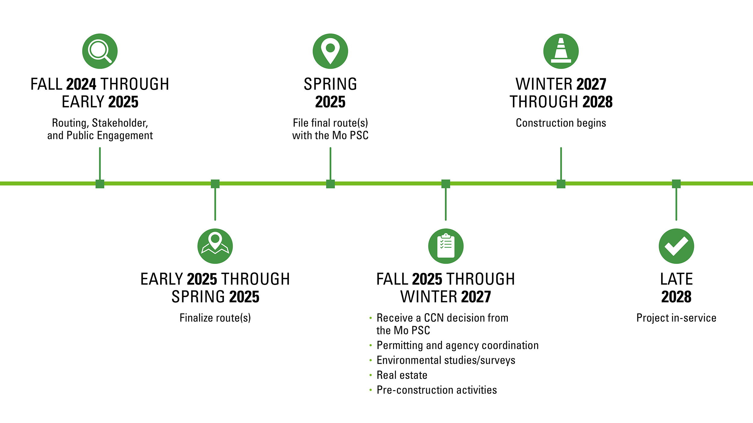
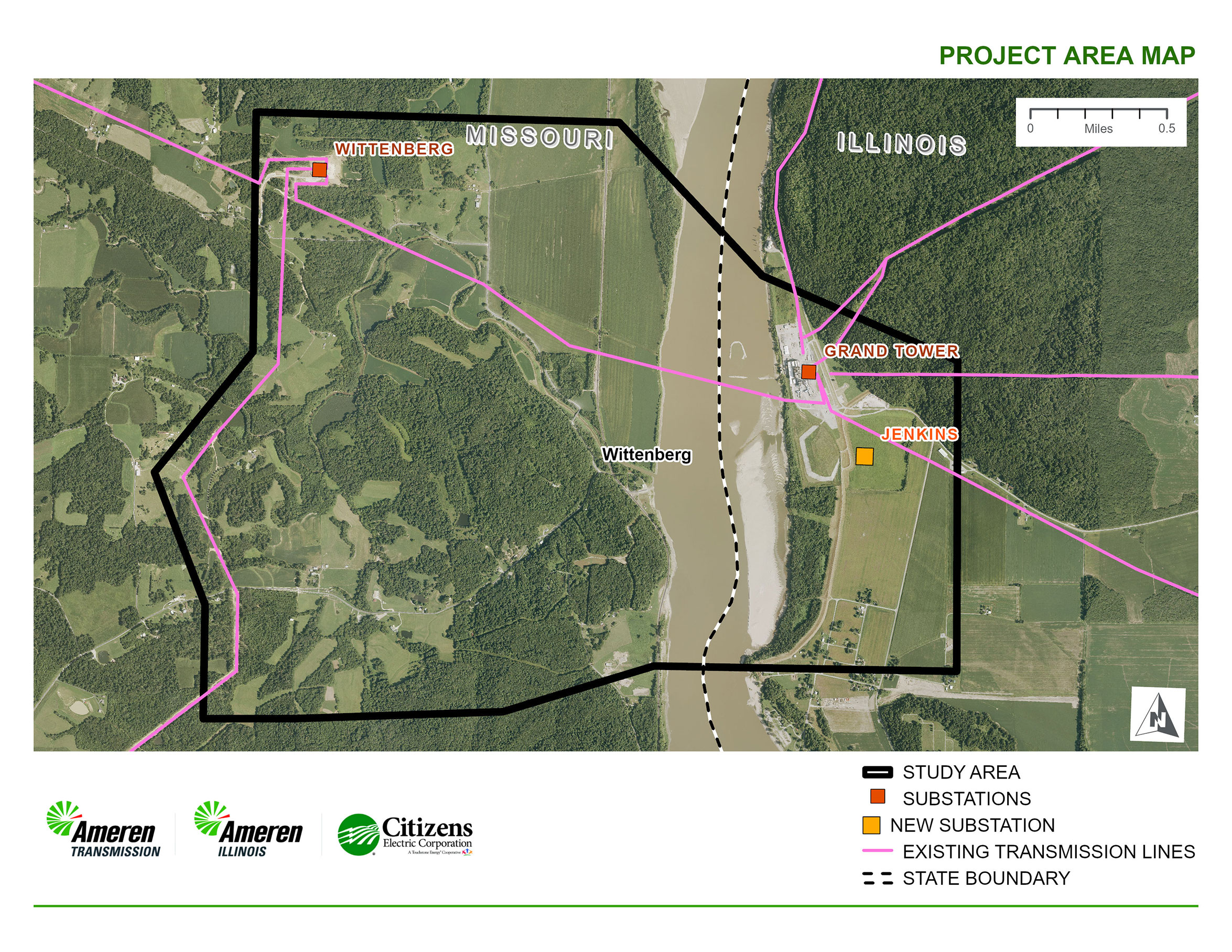
Grand Crossing logo

Central Illinois Grid Transformation Program

Central Illinois Grid Transformation Program Website
  • Study Area
  • Preliminary Corridor
  • Existing Substation
  • New Substation

Tip: Click on the series of icons here to learn more about the project!

Tip:Change how the map looks by choosing either the “map” or “satellite”

Tip:Click on the Legend to learn more about what is shown on the map.

Tip:Enter an address here to locate it on the map.

Tip:Click here to leave a comment on the interactive map at a specific location for our team to review.

Tip:Click here to leave a general comment for our team or sign-up for the mailing list.

Tip:Click here to return to the project website.

Project Overview and Benefits


Ameren Transmission Company of Illinois (ATXI), in collaboration with Citizens Electric Corporation, is proposing the Grand Tower Crossing Project (Project) to improve energy reliability for local communities. This Project includes the construction of a new, approximately 4-mile, 138 kV transmission line to connect Citizens Electric's existing Wittenberg substation in Perry County, Missouri across the Mississippi River to Ameren Illinois' existing Grand Tower substation in Jackson County, Illinois. The proposed Project also includes upgrades to the Grand Tower substation. The goal is to have this new line in service and providing benefits to the local community by the end of 2028.

Project Benefits

  • Improving energy reliability for the surrounding region and local communities.
  • Increasing transmission capacity to meet changing energy needs.
  • Promoting access to diverse energy sources.
  • Growing economic development opportunities.
Project Area Map

Click on image to enlarge.


Anticipated Schedule

The program is expected to be in-service in late 2028.

Program schedule

Click on image to enlarge.

  • Fall 2024 through Early 2025 - Routing, Stakeholder, and Public Engagement
  • Early 2025 through Spring 2025 - Finalize route(s)
  • Spring 2025 - File final route(s) with the Mo PSC
  • Fall 2025 through Winter 2027 - Receive a CPCN decision from the Mo PSC, Permitting and agency coordination, Environmental studies/surveys, Real estate, and Pre-construction activities
  • Winter 2027 through 2028 - Construction begins
  • Late 2028 - Project in-service

What is Energy Reliability?


Our energy grid is similar to our road system in the way it allows energy from generation sources to travel short or long distances, as needed, at any given moment. On the road, when your main route is closed for construction, you review your options and find an alternative. In some cases, alternatives just don't exist, or they can't handle the increased traffic, and users experience backups.

The energy grid is no different! If a large storm were to impact multiple transmission or distribution lines or “routes” in your area, local homes and businesses would be served by a lower capacity lines which could lead to reliability issues in the area.

With this project, we can add more capacity or “alternate routes” to meet the changing needs in your community!

Did You Know?

Almost the entire Eastern half of the United States is electrically interconnected.

Electricity is generated within our grid from diverse sources and sent onto the transmission system. After the energy is generated, it is transferred along transmission lines to substations. The substations then convert the energy to a lower voltage and send the energy to area homes, businesses, and communities through distribution lines where the electricity is needed.

As communities change and our grid evolves, energy sources transition and new sources of energy are developed, substations are built or upgraded to meet the energy demand and expand the system's ability to handle more energy from various points of generation.

Structure Design

At this time, we anticipate using galvanized steel monopole structures and lattice structures for the river crossing.


Monopole Structure Snapshot

  • Voltage: 138 kV*
  • Height Range: 80-140 feet tall (typical)
  • Span Length: 800-900 feet (average)
  • Structure: Single-shaft steel poles
  • Structures per mile: 6-8 (average)
  • Foundation: Drilled concrete pier foundation: 7 - 12 ft diameter (typical)
  • Conductor Clearance: 25 feet (minimum)
  • *138 kV with the potential of a future 345 kV circuit
Map

Click to enlarge

River Crossing Structure Snapshot

  • Voltage: 138 kV*
  • Height Range: 150-490 feet tall (typical)
  • Span Length: 2800-4000 feet (average)
  • Structures per mile: 1-2 (average)
  • Conductor Clearance: 25 feet (minimum)
  • Foundation: Driven concrete and steel pile: 7 - 10ft diameter
  • Structure: Steel lattice towers or tubular towers
  • *138 kV with the potential of a future 345 kV circuit
Map

Click to enlarge

Routing Process

Routing a transmission line is a phased process. Throughout the routing process, our team will work with agencies, community members and landowners, to minimize impacts and develop a final proposed route or primary and alternate routes. The proposed route(s) will be filed with the Missouri Public Service Commission (MoPSC) in early 2025.


The goal of the routing process is to take advantage of Opportunities while understanding and minimizing impacts to Sensitivities and adhering to Technical Guidelines and Statutory Requirements.

Use data from publicly available data sources and federal, state, and local agencies to create and verify the project area.

Consider existing utility corridors, existing land use, resource areas, natural environment data, and field survey data to help minimize impacts while providing a feasible route opportunity.

Create a study area after analyzing and gathering data.

Using data collected from stakeholders and federal, state, and local agencies and the four categories of routing criteria - Opportunities, Sensitivities, Technical Guidelines, and Statutory Requirements - to develop preliminary Route Corridors.

What is a route corridor? A narrowed area being considered for a transmission line. The route corridor is narrower than the original study area, and wider than the right of way that will be needed for the construction, operation, and maintenance of the line.

  • Opportunities
  • Field lines
  • Property lines
  • Section lines
  • Roads
  • Utility corridors
  • Sensitivities
  • Agricultural conflicts
  • Airports/VOR
  • Cemeteries
  • Communication Towers
  • Conservation Areas/Nature
  • Preserves
  • Contaminated Areas
  • Cultural/Historic Resources
  • Planned Development (future)
  • Floodplains (more difficult construction and many times have sensitive species)
  • Forest/Grassland
  • Hospitals
  • DNR Resource Lands
  • DNR State Parks
  • Karst Areas
  • Levees/Dams
  • Mines/Quarries
  • Pipelines*
  • Railroads*
  • Recreation/Tourism
  • Religious Facilities
  • Residences (especially large clusters of homes)
  • Scenic Roads
  • Schools/Daycares
  • Sensitive Crops
  • Sensitive Species
  • Streams/Wetlands
  • Wells

*Linear features with additional precautions and studies needed.

Using the routing criteria, as well as input received from stakeholders and community members during phase 1 of public engagement, our team developed Preliminary Route Alternatives.

After careful consideration of feedback from landowners, community members, interested agencies, and local officials Ameren Transmission Company of Illinois (ATXI) and Citizens Electric Cooperative will file proposed route(s) with the Missouri Public Service Commission (Mo PSC) in early 2025.

Agency Coordination

Our team coordinates with federal, state, and local agencies regarding protected or sensitive resources within the project area. Sometimes additional permits or approvals from these agencies are necessary for construction:


U.S. Fish and Wildlife Service

U.S. Fish and Wildlife Service

  • Endangered Species Act, Bald and Golden Eagle Protection Act, and Migratory Bird Treaty Act
Missouri Department of Natural Resources

Missouri Department of Natural Resources

  • Section 401 Water Quality Certificate
  • General NPDES Permit for stormwater discharge from construction site
Missouri Department of Transportation Illinois Department of Transportation

Missouri Department of Transportation Illinois Department of Transportation

  • Road permits
Missouri Department of Conservation

Missouri Department of Conservation

  • Compliance and coordination for state listed species
Illinois Environmental Protection Agency

Illinois Environmental Protection Agency

  • Section 401 Water Quality Certificate
  • General NPDES Permit for stormwater discharge from construction site
Illinois Department of Natural Resources

Illinois Department of Natural Resources

  • State protected natural features and species
  • Illinois State Historical Resources Preservation Act
  • Illinois Human Remains Protection Act
  • NHPA Section 106 Cultural Resources Review & SHPO consultation
Missouri Department of Transportation

State Historic Preservation Office

  • Section 106 Cultural Resources Review
Missouri Department of Transportation

U.S. Army Corps of Engineers

  • Section 404 Clean Water Act
  • Section 10 Rivers and Harbors Act
  • Section 408 Authorization
Missouri Department of Transportation Illinois Department of Transportation

Local Permits

  • Erosion control and road crossing

Real Estate

Once a final route has been approved by the Missouri Public Service Commission (MoPSC), our team will begin real estate discussions with impacted landowners. Our team will continue to keep landowners updated during the easement acquisition process.


Landowner Discussions

  • Land surveys and studies
  • Access roads
  • Structure/line design
  • Right-of-way clearing
  • Compensation
  • Property restoration

Easements

Easements allow our team access for construction, operation and maintenance of the transmission line. In general, the land can continue to be used as before, provided that the use does not interfere with the transmission line.

Real Estate

Construction

Transmission line construction is completed in intermittent phases and will not be constant on landowner property. We will provide more information before construction begins on any landowner property. Construction will begin in Winter 2027 through 2028.


Preconstruction Surveys

Prior to construction, Ameren will conduct surveys to collect information necessary for construction to start. The field data we collect will help our engineers determine the final design and structure locations and will help to minimize impacts to cultural and biological resources during construction. Examples of types of surveys conducted include:

  • Wildlife Surveys
  • Archaeological Surveys
  • Wetland and Stream Surveys
  • Soil Surveys
  • Property Surveys

Construction

On most structures, there will be six major stages of construction including:

Survey structure locations, soil borings, vegetation management and access roads

Assemble structure on the ground

Dig structure holes

Lift structure into hole backfill with concrete

String wires

Energize line and restore easement

Vegetation Management

Safety and reliability are the driving factors behind managing trees, and other forms of vegetation, around our transmission lines. Trees and other vegetation can damage the line and hinder our ability to deliver electric services safely and reliably. They can make the job of storm restoration more difficult, extend restoration times and pose additional hazards to line crews.


To protect the public and reduce the risk of extended power outages, Ameren has a vegetation management program designed to ensure proper clearances around the lines as required by federal and state agencies. The program reduces the potential for damage and allows access for crews to maintain and repair transmission equipment.

This vegetation management work may include:

  • Mowing
  • Manual and Aerial Trimming
  • Removal of Vegetation
  • Inspections
Learn more about Ameren's vegetation management